Marine Protected Areas (MPAs)
This page has information on
MPAs are geographical areas afforded greater protection than the surrounding waters. They are often designated primarily for nature conservation purposes, but can also be used as a fisheries management tool.
The primary objectives of marine nature conservation MPAs centre on the conservation and/or recovery of marine biodiversity. This may involve a focus on permanent geographic features, habitats and/or protection of particular species.
Management measures within MPAs vary. Some are highly restrictive ‘Highly Protected Marine Areas’, which are sometimes referred to as ‘No Take Zones’. In other areas multiple-uses of the marine environment are managed in relation to the area’s designated nature conservation objectives. The second approach is adopted within UK and European waters.
Dependent on the legislation, social and economic factors may also have a role in the designation and management of these MPAs.
Management measures for MPAs are designed to protect the nature conservation features where the MPA is designated.
In UK waters MPAs management measures are implemented by the following regulatory authorities:
- England: IFCAs (from 0 to 6 nautical miles offshore) and Marine Management Organisation (from 6 to 200 nautical miles)
- Scotland: Marine Scotland
- Wales: Welsh Government
- Northern Ireland: DAERA
- Isle of Man: Isle of Man Government
In some MPAs there are restrictions on fishing in specified areas for fishery management purposes, for example to protect spawning fish. Not all MPAs have fishing restrictions.
Where fishing restrictions do exist they may apply only to:
- Specified areas within an MPA
- Certain sizes of vessels
- Certain times of the year
- Certain fishing gear types
For example, demersal fishing or scallop dredging may be prohibited in an MPA in which static gear fishing is allowed.
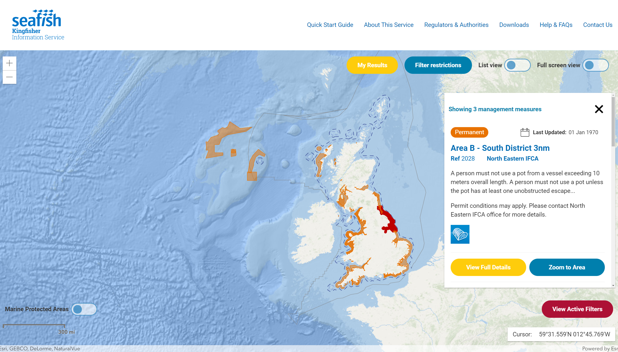
Our Kingfisher team provide information on gear restrictions in waters around the UK. Launched in November 2021, their free online service shows all UK fishing gear restrictions in one place. Restrictions can be viewed via an interactive map from the link below.
We have produced a guide with more in-depth information on MPAs in the context of conservation and fisheries management worldwide.
It includes information on:
- Definitions of MPAs
- Legislative and policy drivers for global and regional MPAs
- Assessment and management of UK MPAs
- Mapping of MPAs and management measures
You can download a copy of this guide from the link below.
This document is part of a series of guides looking at issues relating to sustainability and responsible sourcing. You can find other guides on our website from the links below:
-
Understanding sustainability and responsible seafood sourcing
-
Illegal, Unreported and Unregulated fishing
-
Bycatch and protected species
-
Fish stock assessment and management
For further information on MPAs please contact: